Borders and Border Territories in Europe: a Guided Tour
Traduction :
Charlotte Musselwhite-Schweitzer, professeure des écoles (retraitée) - académie de Rennes
 Mode zen
References | citation |  Deutsch |
  English |
  français
Political Europe is a new continent meaning that its actual political setting is the product of recent modifications. The decades of 1990 and 2000 saw the break-up of several states into new independent entities – recognised or not – which brought more complexity to the continent’s political shape. At the same time, the enlargement of the European Union and reinforced integration have modified the perception and the functioning of its borders. Many internal frontiers have lost importance – but were not removed – whereas the external frontiers, after having been repeatedly pushed back, have had their controlling functions strengthened. While some of these are only “temporary”, waiting for new enlargements, others are perceived as definitive and have sometimes become overloaded with symbolism: they may follow old front lines, cultural or ideological limits, were sanction or reward after a war, open up to more or less close neighbours or mean to protect from a rejected “other”. Problems have moved away from the internal borders of the conciliatory Western Europe (with the exception of the UK since Brexit) which is open for exchanges. They are nevertheless deeply anchored in their external border territories, their operation and their representations.
This article wants to provide a non-exhaustive and evolving round trip of the European Union’s external borders, along with the wanderings of the wide-eyed geographer observing these particular spaces. The frontier between individual and collective representations defines the contours of states as political units and territorial references for those who live in them. Now these representations vary from one state to another and therefore require the definition of a centre. Ideologically assumed choices, implicit or unavowed, they may help understand the adopted strategies, the fears, the potentials. What do these borders actually look like? How can they be understood in their material and their symbolical presence?
1. Perceptions and representations of and in Europe
The borders of Europe as a continent are conventional, derived from old representations (which sometimes hark back to the Ancient Greek) and decisions taken in modern times. The perception the Europeans have of them vary according to the position of their country and the importance of habit and custom.
1.1. A matter of point of view
Europe seen from Riga
Latvia, periphery of Soviet Union (1945-1991)
Latvia, at the periphery of the European Union?
|
Latvia, seen from France, is thus perceived as a state of Eastern or Northern Europe, in every way far from the political and economical “heart” of Europe, on a margin of the continent; but Latvia defines itself not only at the geometrical centre of the continent, but also as belonging historically and culturally to Western Europe. This representation of its place on the continent, found in the school books and atlases of the country, and which is also found in neighbouring Lithuania, has been used since the 1990s to justify and legitimise the country’s wish to become part of EU and NATO when it recovered its independence in 1991. It positions itself as a hinge state in contact with “Eastern Europe”, a name given, from its view point, to Russia and its Belarusian neighbour. This representation is also meant to break away from the Soviet era, when Latvia was in a “top left hand corner” on the maps of the USSR! The country wants to present itself as a bridge between East and West, an entrance door and therefore attractive territory to companies wanting to establish their activities between these two parts of Europe. Representation, political ideology, territorial and geopolitical marketing are all closely entwined. |
|
Europe seen from Moscow
|
From Russia’s point of view astride Europe and Asia, Europe gives access to the sea and is a prosperous and innovating space, but culturally decadent. Nevertheless, since the 18th century, Russia has attempted alliances with it several times, perhaps in the hope of controlling it. With only temporary and partial success. Europe is a space that Russia claims to belong to culturally and ethnically, but from where also originated the invasions of the last two centuries (Napoleon and Hitler), where in the last three decades a Trojan horse under US influence (EU and NATO) has taken shape, expanding dangerously towards it and against which it must protect itself. The remilitarisation of the western borders and the rise of the military budget are therefore a response to this hostile perception of Europe which has allegedly turned its back on Russia. |
|
Europe, seen from London
|
Seen from England, Europe is the continental land mass stretching from the other side of the Channel and the North Sea, where the country historically strived to establish a political balance without ever claiming to belong fully and completely. Historically, the Channel is perceived as a protection, a defence line (against Napoleon, then Hitler, the migrants today) and a factor of cultural differentiation reinforcing its island status. It’s a matter of representation, as the Channel has never really been an obstacle (the legend of Arthur, Norman domination, the royal domain of the Plantagenet). With the loss of Calais (1558), then the cession of Dunkirk to France in 1662, England lost its continental footing. Still, let’s not forget that the kingdom of Hanover in Germany was in personal union with the British sovereigns from 1814 to 1837 … and that the British occupied zone in Germany from 1945 to 1949 stretched from the North Sea coast down to the country’s centre. The status of the Channel Islands is also a reminder that the Channel has not always been a border. | |
")
")


In any case, time is an essential factor in establishing a border in space and in usage. The Iron Curtain for instance, which, from 1947, has cut the continent in two politically, economically and culturally, also generated differentiated and durable representations. It was, until 1989, the ultimate horizon of the European construction in the Western bloc. By the way, what did this name actually involve? The fact is that its reality evolved over time, became more complex, concealing sometimes other borders. Was the Iron Curtain not in itself an ideological construction being at the same instance disturbing, reassuring and simplistic?
1.2. An inherited frontier: one or several Iron Curtain(s)?
“From Stettin in the Baltic, to Trieste in the Adriatic, an iron curtain has descended across the continent.”
This is how Winston Churchill, former British Prime Minister, described the geopolitical situation of Europe in his famous speech held at Fulton University in Missouri on 5 March 1946. This term has from then on been used to qualify the strategic border dividing Europe into two antagonistic and almost hermetic blocs for forty-five years. It remained present in memories and representations, had a durable impact on development standards and mentalities. Nevertheless, when one looks more closely into handbooks and maps, its line reveals differences and uncertainties, and even the concept of division and break-up that this term seems to induce must be questioned.
One or several “Iron Curtain(s)”?
|

Variations on the terrestrial line
The main segment, limited by the towns quoted by Churchill, was submitted to modifications since 1946, as the successive agreements on border questions were still in the making at the time of the speech. First, the city of Stettin on the right bank of the Oder river had been incorporated into Poland which had become communist and was named Szczecin. The durable division of Germany, occupied by the victors of the Second World War, had then led to the creation of two distinct states, West Germany and East Germany, respectively in May and in October 1949, which in fact moved the border line to the west by 250 km, from the Oder-Neisse-Line to the new inner German border near the port of Lübeck. Maintaining the division of Berlin and its following confirmation by the Wall construction around West-Berlin in 1961 had created an enclave.
At the southern end of the line, the city of Trieste had been the junction point between Yugoslav partisans who had conquered the city on 1st May 1945 and the British troops. A demarcation line called the “Morgan Line” had been created on 10 June. Marshall Tito, the Yugoslav leader, then claimed the whole of Istria. The 1947 Treaty of Paris created a neutral republic under UNO control between Italy and Yugoslavia, called the Trieste Territory. It was subdivided into two zones based on the ethnic distribution of its population. It was only in 1954 that the line of the Italian-Yugoslav border was redefined, attributing the city of Trieste to Italy, but its hinterland to Yugoslavia. As a consequence, there was an access strip connecting the city with the rest of Italy.
In 1955, an agreement between the occupying forces led to the evacuation of Austria, the reunification of Vienna and the neutralisation of the territory. The Iron Curtain, which until then had separated Upper Austria (US-occupied) and Styria (British occupied) from Lower Austria and Burgenland (Soviet-occupied) moved 160 km to the east, to the Austro-Hungarian and the Austro-Czechoslovakian border.
In the meantime, the civil war that broke out in Greece in February of 1946 between nationalists and communists had led to the latters’ defeat and the addition of the country to the Western bloc, with its still uncertain prospects back in 1946. The northern borders of Greece were sealed from that time on, the more so in the light of territorial intentions of its neighbours with their still recent borders which had resulted in several wars since the beginning of the twentieth century. The country joins NATO in 1952. Its relations with Turkey were notoriously bad since the expulsion of the Greek population from Anatolia in 1923. The Greek-Turkish border was mined, the Evros river being considered as the main defence line facing Turkey. The border villages of Bulgaria and Turkey were placed under special military regime. Another segment of the Iron Curtain thus connected the Adriatic and the Black Sea. Beyond, it stretched along the Turkish-Soviet border.
From its creation in 1949, NATO had in Europe a direct border of 196 km with the USSR, in the north of Norway (the USSR having annexed the previously Finnish region of Petsamo in 1944), which logically extends the Iron Curtain.
An important maritime dimension
The Adriatic, Black and Baltic Seas were closely monitored because of the differentiated membership to the two blocs of the states on the opposing coasts. Turkey joined NATO in 1952, facing the Warsaw Pact fleets on its own.
The delineations of the Iron Curtain are mostly represented on their continental parts only. Nevertheless, the separation was also effective in the seas, with very visible defensive installations in coastal and island regions. The Iron Curtain stretched through the Baltic: the Swedish island of Gotland, the centre piece of Swedish military defence, was demilitarised as late as 2005. In fact, the USSR had strongly militarised the Baltic coast, restraining or banning its access to local populations. The beaches of Courland were regularly raked in order to detect attempts of escape, and a gigantic radar was built in the secret town of Irbene (Latvia). In the Adriatic, it was the Yugoslav island of Vis, opposite Split, which didn’t allow access to foreigners until 1989 because of its strategic position.
Finland and Yugoslavia, two states between two blocs
Finland presents an ambivalent state of affairs. Neither aligned with the USA, nor occupied by the USSR (with the exception of the naval base of Porkkala, ceded to the USSR for fifty years back in 1944, finally restituted in 1956), it had signed a treaty of friendship and cooperation in 1948 guaranteeing the security of the USSR as well as the Finnish national independence. Finland adopted a strict neutrality, not engaging in any measure that could threaten its eastern neighbour, a policy which has been called “finlandization” (a controversial name, at the same time synonymous with neutrality, renunciation of full exercise of sovereignty but also maintaining democracy and independence). It refused the Marshall Plan and NATO-membership (until 2022), but adopted resolutely democratic institutions and a market economy which link it nonetheless to the Western camp. No “Cold War” between the two countries, but the USSR established a similar border monitoring system as on its other western borders, several kilometres deep.
Yugoslavia presents a particular case because of the falling out between Tito and Stalin since March 1948. The country was excluded from the Kominform and banned from the Eastern bloc. Belgrade refused to join the Warsaw Pact in 1955 although a reconciliation had taken place in the meantime. This exclusion resulted in the isolation of the country within the Eastern bloc. Its role in the Non-Aligned Movement gave it a particular status. Although being a communist country, it has remained open to western tourists, whereas it decided to close its borders with the other countries of the Eastern bloc during the crises of Budapest (1956) and Prague (1968), fearing an intervention of the Red Army. Tourists from West and East could therefore mix and mingle. This explains why the maps displaying the Iron Curtain shows a double area at times, placing Yugoslavia in an in-between zone, not unlike a sluice between the blocs. In the case of Albania, it made the choice of total isolation, closing and fortifying its terrestrial borders both with Greece, of the Western bloc, and with Yugoslavia, considered ideologically “deviant” and a potential threat to the country’s sovereignty.
There was thus construction and evolution in time of the delineation and the nature of the Iron Curtain: sometimes a militarised physical barrier, strongly monitored, sometimes a more or less accessible passage for visitors of both blocs, sometimes a wall between two countries of the same bloc. Its demarcation changed as the emerging destinies of the bordering territories became more tangible. So it did not only run from the Baltic to the Adriatic, but from the Barents Sea to the Caucasus, through the Balkans and the Black Sea, extending to Asia, going by the name of “Bamboo Curtain”. In fact, there were several Iron Curtains during different periods, marked by the geopolitical changes in international relations.
However, there were other deep internal splits within both blocs, which sometimes led to the construction of further defence installations, revealing real tensions often concealed under the bloc logic and a polarised view of international relations.
The Iron Curtain has become part of European history, and, although neither missed nor preserved, it has become in places an object of local heritage. Commemoration or simple tourist attraction, there is now a cycle route along its old line.
8 km from Bratislava in Slovakia, the village of Devin lies in the shade of medieval ruins overlooking the confluence of the rivers Morava and Danube, remains of an old border between Hapsburg Austria and the Kingdom of Hungary. Destroyed by Napoleon’s army in 1809, it saw the construction of a column in 1896 to celebrate the millenium of the Hungarian Kingdom, which column was then blown up in 1921 by the independent Czechoslovakia. The size of the dykes along the Danube and its tributary still shows the extent of the monitoring system installed in 1947, although the eastern part of Austria was then under Soviet occupation (until 1955).
") |
 |
") |
|
An abandoned building is still facing the river. At the confluence, a monument was erected to the victims of the Czechoslovakian regime after 1947 and of the Iron Curtain. An interesting aspect of the former no man’s land is that it has turned out to be an asset for protecting biodiversity: the whole area is classified Natura 2000. Today, the Morava and the Danube separate Austria and Slovakia, but the border has disappeared from the most recent maps of Devin and its cycle route. Cruise ships and barges navigate the Danube which has been under international rule since 1922. |
|


1.3. The multiplication of borders in Europe since 1989
The political set-up of the European continent was marked by stability during the Cold War from 1947 to 1990: there was neither change of borders nor creation of a state during that time. It was, though, reshaped several times during the last three decades because of the German reunification and the break-up of the USSR, Yugoslavia and Czechoslovakia, all taking place according to specific timescales and terms. All this has led to the multiplication of borders and an increased political fragmentation.
|
Stable and unchanged borders between 1945 and 1989: 30 states in 1945, 32 in 1964 (Cyprus and Malta).
|

New states have appeared on the political map of Europe, like Slovakia or Slovenia. Others re-emerged after having been incorporated in a larger entity for a long time (50 years for the Baltic countries, 88 years for Montenegro and Serbia); others only had an ephemeral and contested existence, like Ukraine and Georgia between 1918 and 1921. Bosnia only existed as a distinct region under Austrian administration (1878-1908), Croatia only as a puppet state under Hitler (1941-1944). Moldavia stayed torn between an improbable incorporation into Romania, of which it had been part from 1918 to 1940, and the difficult emergence of its own identity. Add to this de facto borders, non-recognised, delineating self-proclaimed republics, all concentrated in the former Soviet space.
Secessionist states around the Black Sea (2025)
|

These new borders mostly cover former administrative or ancient limits of imperial possessions. They have a history as limits. Often symbols of recovered or newly acquired sovereignty, they are sometimes disputed or have unclear delimitations, especially in the Balkans. Their normalisation is a necessary stage to resolve litigations and to integrate the European Union, this suprananational entity which has asserted itself in the second half of the 20th century to establish durable peace on the continent.
2. The eastern border of the European Union
The EEC (European Economic Community) originally formed a continuous European land entity, extending towards north, south and east following successive enlargements. In doing so, the frontier line increased considerably both on land and in the sea. The reinforcement of the Union prerogatives in border management after the Treaty of Maastricht 1992 had pushed back to the outer frontiers the control of the flows that were traditionally in the hands of individual states. This border however, has a specific profile and operation.
2.1. Continuity and enclaves
The borders of the European Union can be terrestrial or sea borders both in Europe and overseas. Other than the outer envelope, there are three big enclaves inside the EU, formed by the West Balkans, Switzerland and Liechtenstein, and the Russian enclave of Kaliningrad. Added to these are the enclaves of Andorra, Monaco, the Vatican and San Marino. These states have, however, open borders as well as conventions with the EU or its members for certain government functions (foreign affairs, defence, mint…).
|
Enclaves in the European Union |
Kaliningrad Oblast |
")

The break-up of the USSR in 1991 and the independence of the Baltic states have physically separated the Kaliningrad Oblast from the rest of Russia. The integration of Poland and Lithuania into the European Union in 2004 reinforced the cutoff of the enclave from the surrounding territories. In reverse, because of this Russian enclave, the Baltic countries’ only connection with the EU and its land transportation networks (road, trainline, energy cables) is the short Polish-Lithuanian border (90 km).
 Read also: Clara Loïzzo, « Kaliningrad : une exclave territoriale russe à haute valeur stratégique », Géoconfluences, décembre 2023 [in French]. Read also: Clara Loïzzo, « Kaliningrad : une exclave territoriale russe à haute valeur stratégique », Géoconfluences, décembre 2023 [in French]. |
Evolution of the length of the eastern EU border since 1989
*Including sea borders (Baltic, Black and Aegean Sea), i.e. 8,651 km of land borders.. |
|
The question of the EEC borders did not arise when it was created in 1957, considering the geopolitical reality of the continent: it was cut in two by the Iron Curtain, a “hot” border during the Cold War, a sealed border, closely monitored on both sides. The dismantling of the Iron Curtain opened new horizons for extension and therefore posed the question of future frontiers, even ultimate frontiers of the communal project. Would they be imposed borders? Ideal borders? Reasonable borders? These borders do not all have the same degree of importance regarding their issues, the relationship of the neighbour state with the EU and its own level of development. Where the borders of Switzerland and Norway are open in the Schengen space, the eastern borders are heavily guarded because of the migrant crisis.
The length of this border has greatly increased through the successive enlargements: it has doubled in fifteen years. Seen from Western Europe, it has moved away, been pushed back. It is thus absent from everyday life, until migrants saved in the sea near Sicily or in the Aegean remind us of its reality. Since 1995, the EU has had a border with Russia. The membership of Turkey – not on the cards these days – would give it a frontier with Iran, Iraq and Syria.
This border comes at a cost for the member states, for it has to be secured: barriers, fences and even walls have reappeared. It is at the external borders of the Union that reinforced checks, patrols and permanent surveillance are carried out. The agency Frontex was created for that purpose in 2004, it became the European Border and Coast Guard Agency in 2016, headquartered in Warsaw.

The eastern border of the EU does not aim to become a new Iron Curtain. Nevertheless, with the exception of the Euro-Ukrainian and the Euro-Moldovian dyads – both candidate states with borders considered to be “provisional” – it has become a fault line of the continent, between two models of governance, two different ways of thinking, two organisational “centres” which have become rivals and hostile. The European regions along the eastern border are among the least affluent and developed of the 27. They are each situated at national peripheries, sometimes like a dead end, with undiversified and slow economies and shrinking populations. For these reasons, they receive community funding, which tends to deepen the development gap with the border regions of the neighbouring states, as revealed by GDP per capita data. This new “development frontier”, alongside which one finds differentials of 1 to 5, is burdened by the economical and human consequences of the war in Ukraine.
The eastern border of the European Union: a deepening development frontier
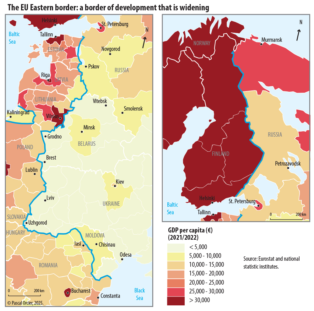
2.2. The border EU – Russia
 |
|
EU and Russia have shared a common border since 1995, when Finland became member. In 2004, new sections were added to this border of 1300 km (Poland-Russia, Lithuania-Russia, Estonia-Russia and Latvia-Russia), making it the longest land frontier that the EU shares with a neighbour (2284 km). This border comes with a considerable symbolic and memorial meaning. To the Baltic states, it is the symbol of independence dearly acquired in 1920, restored at the price of several border guards killed in 1990; it also reminds of the invasion by the Red Army in May 1940 and the battles fought in 1944, a prelude to the renewed invasion of the region by the USSR; to Estonia and Latvia, the memory of having their land amputated (Setumaa for Estonia and the district of Abrene for Latvia). For Finland, it is the memory of the Winter War (1940) and the Second Soviet-Finnish War (1941-1944) resulting in the loss of Karelia, the Petsamo District and the area of Salla.
|
Territorial losses of Finland in 1947. |
Neito, symbol of Finland, before and after the losses of 1944. |
 |
|
The small Finnish town of Imatra has a frontier museum, opened in 1989, which retraces the history of the country’s borders. Finland’s loss of Karelia in 1944 triggered the displacement of over 400,000 people. The function of the Saimaa Canal (built between 1845 and 1856) that linked the interior Finnish lakes with the now Russian port of Vyborg, was durably disturbed. Finland lost its access to the Barents Sea. The national iconography had to adapt the popular representations of the figure of Neito, the national symbol, to the modified contour of the country. |
||


|
(Left) Monument to the memory of the « Walloon Legion » at Sinnimae (Estonia), a few kilometres from Narva. Pascal Orcier, 2008. The battles of 1944 opposing the Red Army and the Wehrmacht were supported by anti-Bolshevik volunteers from Western Europe as well as from drafted Balts who feared the return of the Soviet invader (the first occupation, from May 1940 to June 1941 had resulted in the break-up of the states, the deportation of opponents and local politicians and numerous cases of torture). |
(Right) Commemorating Soviet column at Narva (Estonia), P. Orcier, 2007. As an echo to the previous memorial (left), there are many steles on the left bank of the Narva dating from the Soviet period, commemorating the human sacrifices of the reconquest of the region from the nazi army. The communist symbols, although being associated in Estonia with a totalitarian and criminal ideology, are still present. |
")
")
|
(Left) Orthodox church of the Old Believers, in Mustvee (Estonia), P. Orcier, 2008. On the Estonian and Latvian side of the border still lives a religious minority, the Old Believers. They are dissidents of the Russian Orthodox church who always refused a reform imposed by the patriarch of Moscow at the beginning of the 18th century. In order to follow their cult without persecution, they settled on the western side of Lake Peipous. |
(Right) Bridge over the Narva and fortresses of Narva (Estonia) and Ivangorod (Russia), P. Orcier, 2007. The Estonian city of Narva, an emblematic site of the border, is mostly Russian-speaking and the main land passage between the two countries, on the axis Tallinn-St Petersburg. The only bridge over the Narva river cannot cope with the road traffic. The two fortifications facing each other are linked to the old frontier which, from the 12th to the 18th Century, separated Danish Estonia, then the Livonian Order, and the Swedish possessions of Russia. |
")
 et Ivangorod (Russie)")
") |
Dune of the Courland peninsula at Nida (Lithuania), P. Orcier, 2004.
|
")
Nida is an ancient Estonian fishing village which is the “End of the World” one reaches after crossing the Courland lagoon at Klaipeda and travelling through some thirty kilometres of pine forest. On the other side of the strip of land separating the lagoon from the Baltic Sea stretches a long sand beach. The Russian border crossing is rarely used because of its distance from the main through routes and its being in the middle of a protected natural space (national park…). The dune that dominates Nida offers a panoramic view over the border. An orientation table mentions, on the Russian side, the existence of a POW camp for French prisoners during the Franco-Prussian war of 1870.
|
Petrol Train in transit at Kybartai (Lithuania), P. Orcier, 2008. |
Kybertai is the main passage point for Russian trains that transit through Lituanian territory to join Kaliningrad. The small town lives to the beat of the opening and closing of level crossings letting through passenger trains as well as hydrocarbon convoys and freight trains. Russian passengers are required to carry a transit document. |
")
On the Russian side, the border is a very visible fact, through military presence and recurring security issues, often inherited from the Tsarist and Soviet regimes.
 |
The Russian city of Sovetsk on the Neman river is a former Prussian city and former staging post on the road from Königsberg (Kaliningrad today) to St Petersburg. A border town of the German Empire until 1945, it regained this status in 1991 for the Russian Federation. The German period buildings of the historic town centre are falling apart due to lack of maintenance. |
|
Sign on the Neman river, on the Russian bank (P. Orcier, 2008) « Attention border area, no passage no crossing ». The beach on the river bank is well frequented during the summer. On the other bank, Lithuania. |
Queen Louise bridge, at Sovetsk, on the Russian bank (P. Orcier, 2008). Prussian vestiges of the 18th century marked the entrance to the German Empire, when Russia was … on the other bank! |
|
Warships at Baltiysk (Kaliningrad Oblast, Russia), P. Orcier, 2008. |
|
|
Russian sailors at Kronstadt (Leningrad Oblast, Russia), P. Orcier, 2008. The region of St-Petersburg hosts important military and naval schools as well as garrisons. Kronstadt, a military town near St-Petersburg, is their symbol and pride. Kaliningrad,for its own part, houses the Baltic Russian Fleet and and has considerable military installations which are more or less operational. |
Fortified isle at Kronstadt facing St-Petersburg (P. Orcier, 2008). From the beginning of the 18th century, Russia established itself around the Baltic Sea. The foundation of St-Petersburg in 1701 by Peter the Great necessitated fortifying the Gulf of Finland’s coasts. |
|
After 1991, Russia had to adapt its territory to its new borders after the independence of its former peripheries. At first, they were not protected. In 2006, by presidential decree, the frontier zones, where the FSB (former KGB) was in charge of border guard, were expanded, increasing from 5 km to 30 km from the border line itself. Vast spaces were thus subtracted from local control. The extension of this frontier zone, as defined by the Russian state, recovered more or less its dimensions of the Soviet period, almost 550,000 km², which represents the surface of metropolitan France! |
Map section of the surrounding area of Vyborg. Source: map of the Karelian isthmus, 2006, 1:160,000, Discus, St Petersburg. The entrance to the frontier zone is marked by a specific symbol on Russian maps, a hand (here: violet circle). On the ground, specific signs “Border Control Area” are erected along the roads. |


")
")

")
")
2.3. The Border EU-Belarus
 — Biélorussie") |
An authoritarian state subjected to European sanctions because of human rights abuse, Belarus is the most isolated of the states in the neighbourhood of the European Union, led by the iron hand of Alexander Loukachenko since 1994. Turned towards Russia, it sees in the recent extension of EU and NATO some suspicious American activism. Its western neighbours (Poland, Lithuania and Latvia) are the most interested in increasing their economical presence there, wishing to intensify their trade exchange with this still quite closed country. It is true that they share a history and 1081 km of borders. |
|
Former road near Medininkai (Lithuania) P. Orcier, 2008. |
Here in Medininkai, a rural and sparsely populated zone of Lithuania, the old road, having become obsolete, was cut off pure and simple. The tarmac had been dug up, giving view of the sand a few inches deeper: it is now easier to control attempts of passage. The two border stones demonstrate that the security device is entirely located in Lithuania. The guard post of Medininkai is also a memorial for the Lithuanians who remember the front guards killed in 1991 by troops of the Russian ministry of the interior trying to regain power over this republic which had declared its independence and established a border post. |
|
Railway line at Salcininkai (Lithuania). P. Orcier, 2008. |
Slightly further south at Salcininkai, the old railway line from St Petersburg to Warsaw only sees freight trains. Its use for international passenger traffic is no longer adapted to the requirements of the populations, the outline of the borders and the visa regime explain its state of abandon and the lack of investment. |
|
Road towards the frontier near Druskininkai (Lithuania) P. Orcier, 2008. |
In Druskininkai, the former spa town, the old train line link with Belarus no longer exists. The pine forest, associated with ancient pagan traditions, is now crossed by cycle routes. Road signs show the Lithuanian name of the Belarusian city of Grodno just before the entrance sign in the border area (pasienio ruozas: border section). |
 — Biélorussie")
 — Biélorussie")
 — Biélorussie")
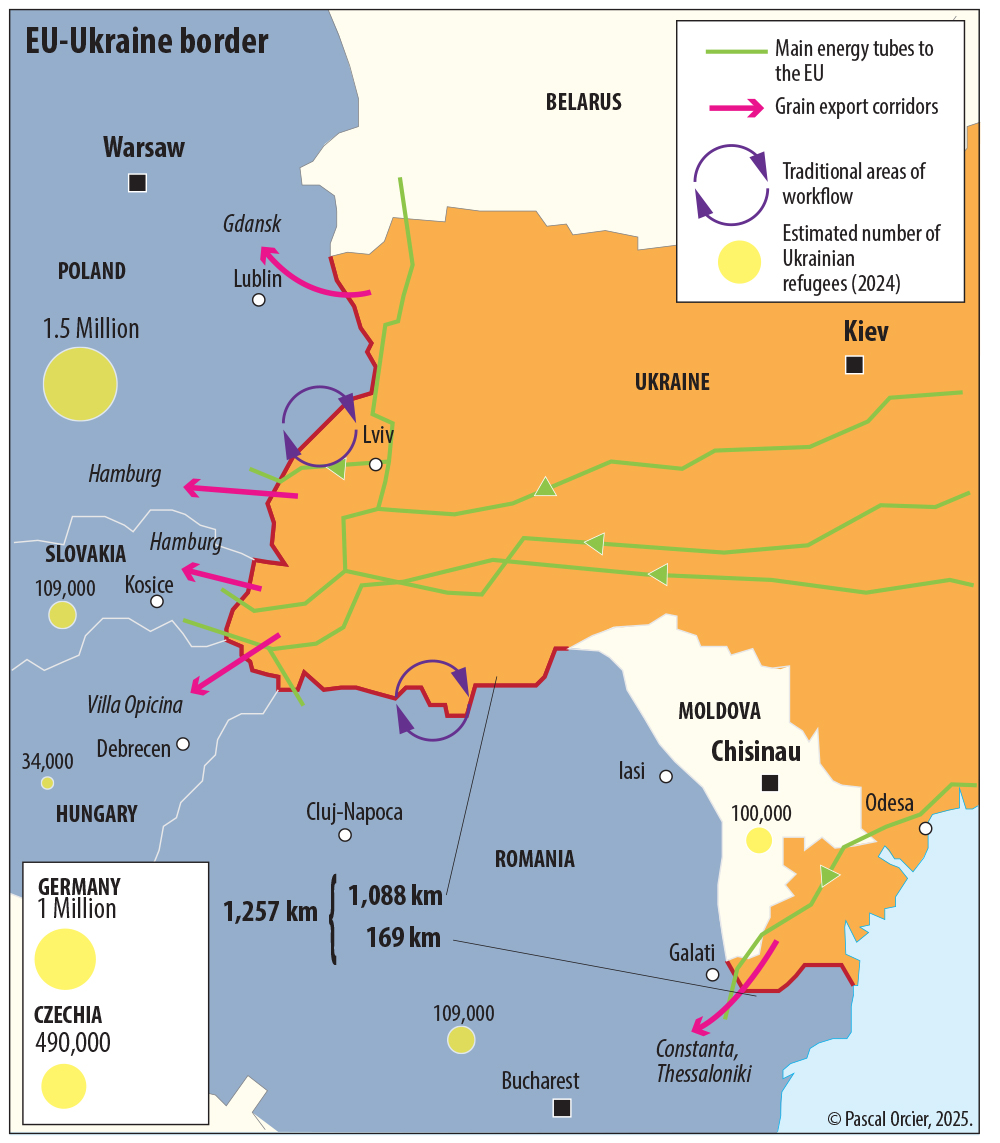
2.4. The border EU-Ukraine
The EU-Ukraine border consists of two segments on either side of Moldova, and involves four states of the European Union: Poland, Slovakia, Hungary and Romania. The main passages are in Poland, with which Ukraine has historical links. On the other hand, there is no direct land passage south of Moldova. The energy infrastructure inherited from the USSR is concentrated in the central part, the Carpathians. This is also the part of the border where the cross border relations are at their most intense, with the presence of Polish, Hungarian and Romanian linguistic minorities on the Ukrainian side. In the southern part, on either side of the Danube estuary, live Pomak and Gagauz minorities, also present in Moldova.
The war since 2022 pushed many Ukrainians, escaping the combat zones, towards the neighbouring countries, mainly women, children and elderly people, who received the status of refugees. The west of Ukraine also houses many displaced persons. NATO reinforced its presence and guarantees the training of Ukrainian troops.
2.5. The border EU-Moldova
 — Moldavie sur le Prout") |
|
The EU-Moldova border has the particular feature of being completely defined by the course of one river, the Prut. Its length of 681 km stems from the myriad meanders of that river. This border was a USSR frontier before 1991, leaving a visible defense heritage: few passages, the keeping of riparian woodlands and weak urbanization on the river banks, and also the existence of a train line following the river on the Moldovan side for monitoring purposes (see below a similar installation along the Greek-Turkish border). The difference of track gauge between previous USSR and its former satellites made it obligatory to swap bogies in the border train stations, extending the travel time of the passengers who then often preferred using buses. Romania, which had been attempting to join the Schengen area for several years, had to reinforce its controls, although it still had fans of a reunification with Moldova (which was part of Romania from 1918 to 1940). The border is part of a linguistically unified area. The Romanian county with its seat of Iasi is, by the way, called county Moldova. The persisting poverty has led to increased smuggling. The natural layout of the border lends itself to throwing tyres filled with cigarette cartons from Moldova, easily picked up downriver on Romanian side and then hawked by street vendors.
 — Moldavie, sur le Prout")
The outline of the Romanian-Moldovan border on the Prut river at the level of Iasi. The river has many meanders, some having been cut off and constituting wetlands.
Completely south, at the level of the Danube, the border passage is unusual. In fact, because of the width of the river delta, no bridge was ever built there to form a direct connection between Romania and Ukraine. Trains and vehicles coming from Ukraine have to cross two kilometres of Moldovan territory (which is the symbolic access of the country to the Danube waterway). In reality, they have to undergo four different controls over less than two kilometres. The subsequent traffic jams during the summer period benefits the vendors established on that section of the road, who are happy to accept Ukrainian hrivnas, Romanian and Moldovan lei as well as euros (and return the money according to what’s left in their box). Romanian police mainly control Ukrainian and Russian passports, because certain nationals of these countries are under European sanctions. There are several daily bus links from Odessa to Western destinations.
3. The borders of the EU in the Mediterranean
3.1. The border EU-Turkey
Bulgaria and Turkey have a long history of tensions which explains the weak opening of the common border. Three centuries of Ottoman domination had won over the medieval Bulgarian kingdom and affected the country that restored itself during the 19th century. It took several wars to push back the Ottomans to the actual border (Treaty of Lausanne, 1923). The Bulgarian-Turkish frontier then became a section of the Iron Curtain (1947-1991) and forbade access for that reason. There are even tanks from the Wehrmacht buried there in 1944 facing the enemy and forgotten until recently. The area was left to the forest. In 2007, it became a part of the external border of the EU. It is the only section of the old Iron Curtain defence system that became a border of the EU.
 — Turquie") |
The land border EU-Turkey is 446 km long, to which one has to add several hundred kilometres in the Aegean Sea (Greece and Turkey do not agree on its delineation) and officially between the north of Cyprus and Turkey (separated by 72 km). On the Black Sea coast, a string of little seaside resorts ends with the village of Rezovo, in a dead-end of the road. |
|
Former entrance to the border zone of Rezovo. P. Orcier, July 2011. |
Three kilometres before one arrives, there is a first barrier topped by barbed wire and a former control post. The typical Balkan village is built on a hill that towers over the estuary of a little river serving as border. |
|
View on the frontier installed on a small river. P. Orcier, July 2011. |
The frontier materialises as two flags on each bank. On the Turkish side, a huge deserted sand beach, on the Bulgarian side, a tiny beach under the village does not let swimmers get away any distance of the shore. Buoys show the border in the extension of the talweg. |
|
View of the Bulgarian village of Rezovo. P. Orcier, July 2011. |
Seen from Turkey, Bulgaria shows off three symbols: an Orthodox church, a source of national identity against the former Islamic Turkish masters; a European flag, pride of a state which recently joined the “club” against a candidate whose adhesion is grinding; and a control tower, although the military threat has disappeared and the sector not being on a migratory route. |
|
« Remember Cyprus » . Large board installed along the road at the entrance of Alexandroupoli (Greece). P. Orcier, August 2002. |
On the Greek side, many hints show the old will to monitor the border. The trainline which connects Alexandroupoli to Bulgaria follows the river Evros (Maritsa in Bulgarian) and is in bad shape and very little used. Near the city, where tourists travel to Turkey, mainly Germans or Turks from Germany, a large board by the roadside reminds them of the relationship Greece has with its neighbour. One sees the island of Cyprus depicted with its northern part dripping with blood, as a reminder of the invasion and occupation of that part of the island by Turkey since 1974. Tags on the board show that its presence is perceived as a provocation nourishing resentment. The map is used here for ideological purposes. |
 et Turquie")
 et Turquie")
 et Turquie")
")
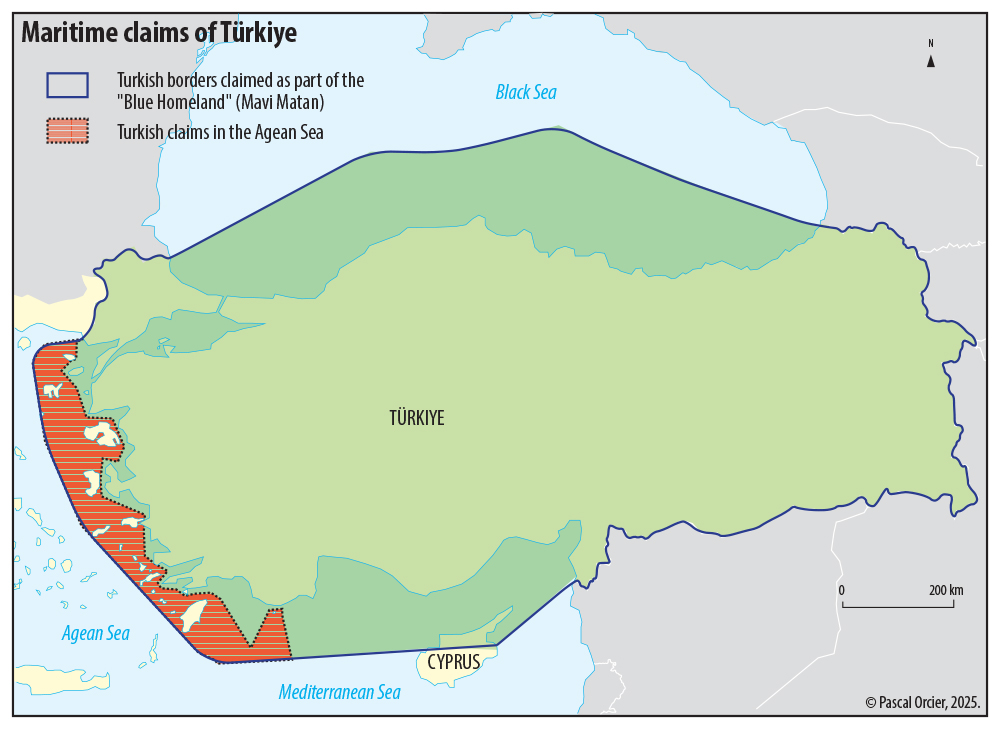
In the course of the years since 2010 and in conjunction with the deteriorating relations between the EU and Turkey, the latter elaborated a new doctrine regarding the extent of the country’s maritime jurisdiction. Called Mavi Matan (Blue Homeland), it amounts to a revision of the Treaty of Lausanne, which defined the country’s borders in 1923, and constitutes a breach of the rules established by the Montego Bay Convention (bearing in mind it has not been signed by Turkey). Considerable resources of gas were then found in the eastern Mediterranean, and, by applying the rule of equidistance starting from the continental coasts on the Aegean Sea, Turkey claimed vast maritime territories. These pretensions were made ignoring Greek sovereignty of its Aegean islands and of bilateral delimitations previously agreed. Turkey signed, in 2019, a delimitation agreement with the Libyan government of Benghazi, which was rejected by Greece and Egypt. Intimidating sea manoeuvres by Turkish warships took place against fishing ships and vessels for underwater prospection, whereas the passage of migrants towards the Greek islands, these EU hotspots, remains a recurrent sticking point.
 |
Pascal Orcier, 2023. |
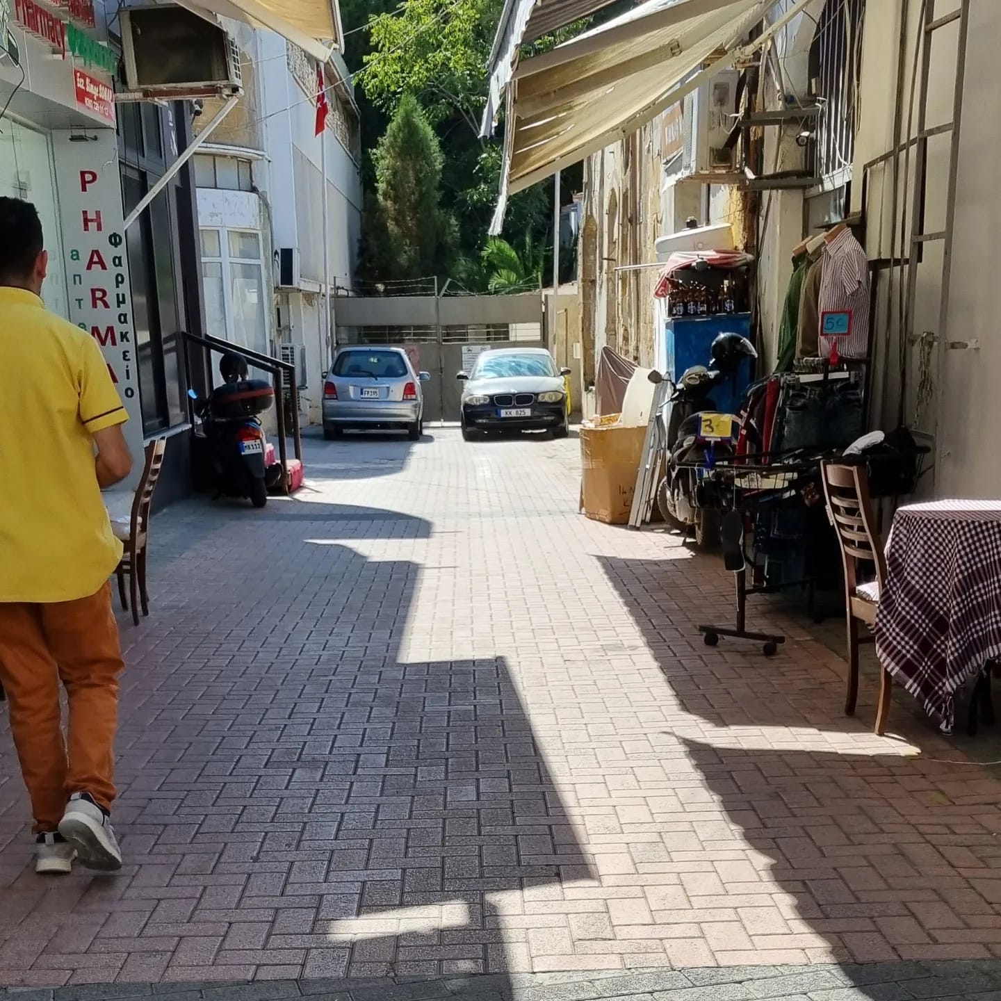
3.2. The de facto border of the EU-Turkish Republic of Northern Cyprus
|
|
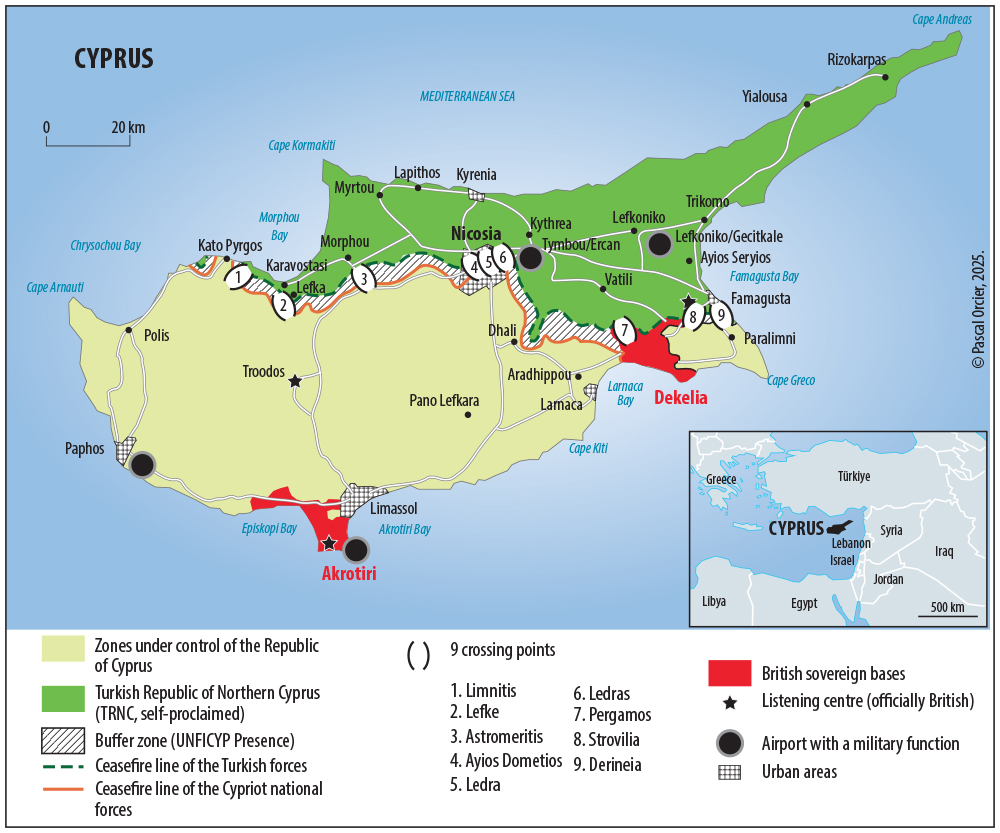
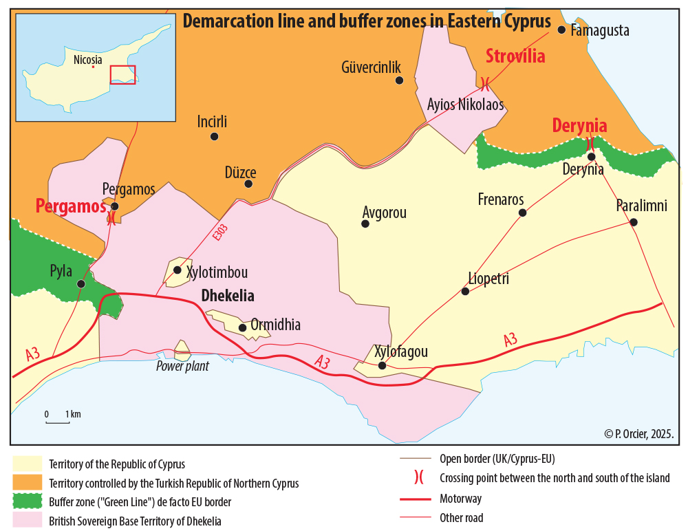
Cyprus features four distinct political entities: the Republic of Cyprus, the Turkish Republic of Northern Cyprus (self-proclaimed, not internationally recognised), the Buffer Zone and the Sovereign Base Areas Akrotiri and Dhekelia (Bristish). The border between these and the Republic of Cyprus is open despite Brexit. It displays a few curiosities: the motorway A6 from Paphos to Limassol crosses twice the territory of Akrotiri and Dhekelia. Roads signs and speed limits are in miles, the GPS clearly identifying the invisible presence of the border in the landscape between Turkey and the United Kingdom! In the sector of Dhekelia, the British territory contains several Cypriot enclaves, and is itself composed of two distinct territories (Dhekelia and Ayios Nikolaos, connected by a narrow strip that includes road E303 ensuring the continuity between the two …) and which also separates the Republic of Cyprus from the Turkish zone. This explains the official length of the border between Cyprus and the UK, 152 km, despite the modest dimensions of the concerned territories: 254 km², that is hardly more than the surface of the city of Marseille! Two passages link the British and the Turkish zones (Pergamos and Strovilia). The UN Buffer Zone, inhabited, and up to 5 km wide, is discontinuous. There are therefore different types of borders on the island, official or de facto, with or without physical barriers.
Inset 1. History of the division of Cyprus since 1974
Since 1974, the Island of Cyprus has been divided. In the south, the Republic of Cyprus with its Greek Cypriot community is the only internationally recognised authority. In the north, the self-proclaimed Turkish Republic of Northern Cyprus (TRNC) has been recognised since 1983 by Turkey alone. It lies in the zone invaded in 1974 by Turkish troups as a response to the coup by ultranationalist Greek Cypriots who wanted the island to be part of Greece. Between the two runs a demarcation line (Green Line) of 180 km where a UN peace force (UNFICYP) of 1200 troups is stationed.
In the 1990s, the island’s partition became again a sensitive subject, when the Republic of Cyprus asked for its integration into the European Union and pushed both sides to restart negociations under UN auspices. In November 2002, the UN presented a plan to serve as a basis for talks between the two opponents. This “Annan Plan” (named after the UN Secretary General), suggesting reunification of the island, saw long negotiations and the elaboration of five successive versions between 2002 and 2004. On 24 April 2004, the Greek Cypriots massively (75%) rejected it following a referendum, whereas the Turkish Cypriots supported it with 65%. The partition of Cyprus was therefore maintained: on 1st May 2004, only the southern part of the island was integrated into the EU. It shows the will of the Greek Cypriots to keep the Turkish community out of the EU, for political and economic reasons, and the failure of the proposed federal solution.
The first consequence was the closing of a recently opened border by the Turkish Cypriot President Denktash after the tense negociations between 2002 and 2004. This “Green Line” with its wall in Nicosia stands as a symbol of the two communities’ partition. But 2004 also marks a sharp break in the island’s evolution as it was the perspective of adhering to the EU that had encouraged the talks between the two communities. They failed though. Furthermore, in February 2005, as anticipated general elections were held in TRNC, the republican party of Prime minister Mehmet Ali Talat, favourable to the UN reunification plan, won the elections with 44,5% of the votes and 24 of 50 seats. The idea of EU adhesion clearly moved the situation forward. The EU has become a major player, taking over from the UN, and from then on, challenges have to be studied in that light.
Cyprus is a major issue for Turkey’s application for EU membership, bearing in mind that the Turks themselves are extremely divided on the subject. This discussion found itself transposed to the Cypriot territory and the “Green Line”, which has also become an external border of the EU, a key space for the control of migration. This situation might deepen even more the development gaps between the Greek and the Turkish parts of the island.
ST, October 2011. Translation CMS 2025.
 |
Since 1974, the Island has been divided in two by the “Green Line”, a demarcation line and buffer zone separating the southern area, which is under the effective control of the legal authorities of the Republic of Cyprus, from the zone occupied by Turkey, the self-proclaimed Turkish Republic of Northern Cyprus. The Green Line stretches from east to west with a buffer zone of up to several hundred metres wide. A UN mission, the UNFICYP, is deployed on the terrain. This demarcation line was closed to all traffic from 1974 to 2002. A first passage point opened in 2003, for pedestrians and cyclists only, followed in 2005 by four more, this time open for cars. In November 2018, the eighth and ninth passage points opened.
In the capital city of Nicosia, the passage point in Ledra Street is for pedestrians only (see photo below). In the adjacent streets, all sorts of walls and barriers can be found.
|
Passage point for pedestrians in Ledra Street in the centre of Nicosia. Photos: S. Bérenguier and N. Segura, October 2022. |
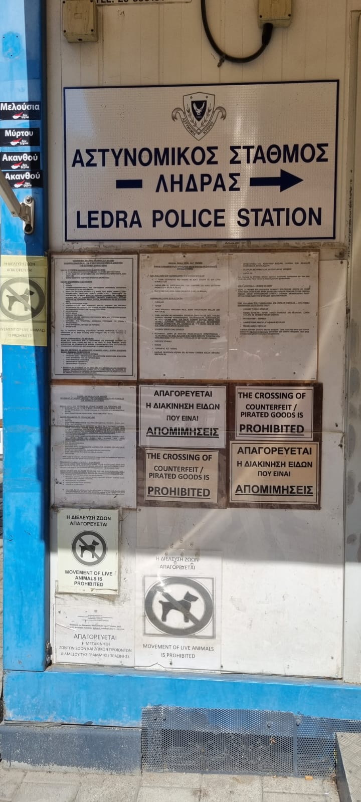 |
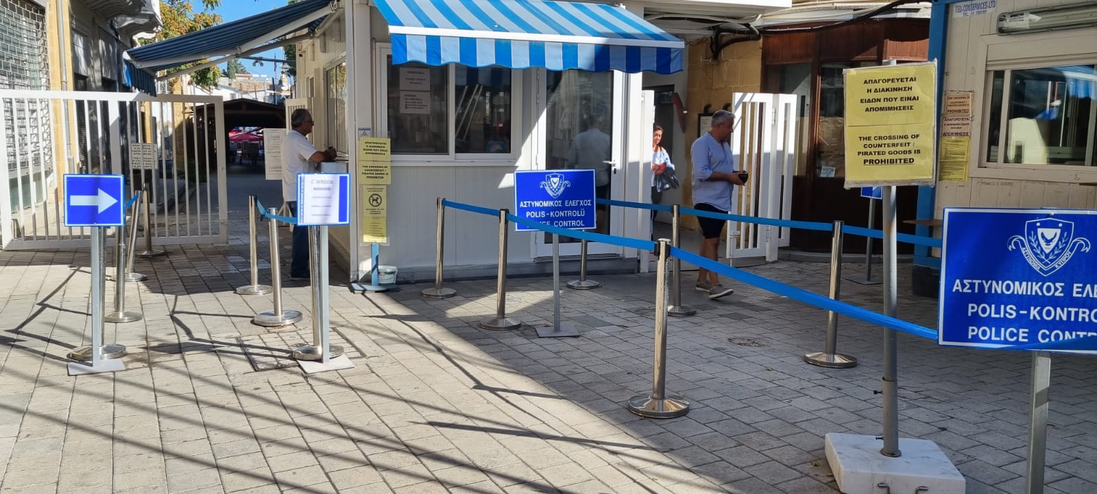
The control post (top left) looks like a vending stall, but trilingual signs are reminders of the real nature of the place. It’s called a “Control Post”, as “Border Post” would implicitly recognize a border. A currency exchange office is nearby, as the Turkish lira is used in the North and the euro in the South. Passports are controlled both on the Greek and the Turkish side. There are more people around at lunchtime. Cars cross at Kermia, three kilometres from the western part of the town centre. However, rental vehicles are not always allowed to use it, unless a specific insurance is purchased at the control post, which might make the day trip less attractive.
On the signs (top right), one finds the information usually present in airports and border posts, particularly concerning counterfeit goods. On the left side, little stickers-not official, this time- show the northern part of the island in red, with several places formerly populated by Greeks and occupied by the Turkish army since 1974: Malounta, Morphou and Akanthou.
|
In Nicosia, the division across the town is revealed by walls like the above. To the left, one reads the Greek slogan “Liberation! Wake up!”, opposing the Turkish occupation and colonisation in the North. To the right, the barrier appears like a space expressing identity: no wall here, but a barricade made of two levels of drums painted with the colours of Greece. The board in front of it informs the reader that the EU financed the renovation of the neighbourhood. Photos: S. Bérenguier and N. Segura, October 2022. |
 |
 |
(Above, middle) On the Turkish side, as indicated by the street sign in the latin alphabet, another condemned former passage. Photo: S. Bérenguier and N. Segura, October 2022. |
(Above, right) The Turkish flag at the cul-de-sac closed by the metal barrier. The Turkish side has more shops, where price tags are in euro. The inhabitants are pragmatic: Greek Cypriots cross the border to take advantage of the more attractive prices of hospitality and food, a regular bazaar being permanently held on the Turkish side. On the other hand, 5 000 workers are supposedly crossing over daily from North to South. Photo: S. Bérenguier/N. Segura, October 2022. |
|
(Left) Seen from the Turkish side, this street is barred by a concrete wall topped with barbed wire. Behind it, on the Greek side, a very visible mast shows both the Greek and the Cypriot flag. Many houses are empty. The carved stone work around the door frames testifies of past grandeur and a certain affluence of the previous inhabitants. This patrimony is under threat today. Photo: S. Bérenguier and N. Segura, October 2022. |
||
3.3. The border EU-Morocco
Between the EU and Morocco, other than often indicated on the maps, the border does not pass in equidistance of the Mediterranean coasts, because of the existence of the two Spanish enclaves (presides) Ceuta and Melilla. Spanish since the 15th century, each of them forms an autonomous community of the Kingdom. Added to which are some isles and islets, very close to the Moroccan coasts which remained Spanish because their control predates the protectorate. All of these territories are claimed by Morocco. The land frontier between the two enclaves and Morocco is 15.9 km long and goes back to Moroccan independence in 1956.
|
|
Whereas Ceuta and Melilla have the lowest income level of Spain, they represent nevertheless isles of wealth and an entrance gate for Europe, for Moroccans who come there to purchase all sorts of produce attractive because of absence of taxes (both cities are free ports and not included in the European Customs Union), to be then sold in Morocco, as well as for sub-Saharan migrants who try to enter it. This situation has justified the installation and reinforcement of complex security systems. Another sea border separates Morocco from the Canaries, another access route used by the migrants towards the European eldorado, and as such, heavily guarded. |
|
Panel with street name in Nador (Morocco). P. Orcier, 2015. |
Interesting positioning, both in terms of function and image, as two Moroccan cities, Tangier and Nadir, present themselves as “Gateway to Europe”. |
|
Bus terminal of Nador (Morocco). P. Orcier, 2015. |
Goods (in this picture, blankets) from Melilla (Spain) are transported in the luggage compartment of the buses from Nador towards other Moroccan cities. |
|
Entrance to the city-enclave of Ceuta (Spain). P. Orcier, 2010. |
With a double barrier, barbed wire and a wide road for the Spanish patrols, the border has received heavy security investments from Spain and the EU. On the Moroccan side, the city appears under the name of Sebta on the road signs, without any mention of the contested border. |
|
Town centre of Ceuta (Spain). P. Orcier, 2010. |
Once past the barriers and warehouses, Ceuta comes across as a “typical” Spanish town in a Mediterranean resort context, dominated by a 16th century fort and with evocative names like “Reyes Católicos street”, “Cervantes Square”… |
|
Train station of Beni Azar (Morocco). P. Orcier, 2015. |
The train station of Beni Azar is the terminus of the Moroccan railway lines just before Melilla. After having been the bridgehead of the Spanish colonisation of Morocco, the town had no more train connection with Morocco after the rails were removed at the end of the Spanish Protectorate in 1956. |
|
Border post of Melilla (Spain), P. Orcier, 2015. |
A line of vehicles at the border post of Melilla. You see the tall blue fences blocking the access, as well as powerful lighting. There is a continuity of the built-up areas of the two countries, and a permanent flow of passengers in both directions, on foot and by car. |
|
Entrance of Melilla, P. Orcier, 2015. |
At the entrance of Melilla, many Moroccans busy themselves around the shops and warehouses. Women, loaded with enormous sacks on their backs, wait to take them to Morocco. |
|
The Peñón de Alhucemas, part of the archipelago of Al Hoceïma, P. Orcier, 2015. |
The Peñón de Alhucemas, 800 metres from the beach. Spanish flags painted on the walls of the fort are reminders of the presence of an invisible border, as well as the actual Spanish flags planted on the nearby isles where access is prohibited. Being signs of sovereignty, Morocco perceives these flags as a provocation. |
|
The Chafarinas Islands, P. Orcier, 2015. |
Between Nador and Saïdia are the Chafarinas, populated by a Spanish military garrison only, they are the last “morsels” disputed by the two countries. They are visible from the outskirts of Ras El-Ma. |
Gibraltar |
|
|
|
Southern Point of the Gibraltar Territory (UK), P. Orcier, 2016. Gibraltar was part of the EU until 31 January 2020, but of neither the Customs Union nor the Schengen Area. The specific regulations applied made this small territory without natural resources economically attractive. The photo combines three symbols. The Rock of Gibraltar in the background is physically one of the extreme points of the European continent. With its characteristic shape it can be seen from far away and marks the entrance of the Mediterranean. In the foreground flies the Union Jack, reminding of the fact that Gibraltar has been British since the Treaty of Utrecht (1713) and wants to stay like that despite Spain’s repeated claims. Between the two, a mosque built facing the sea, financed by Saudi Arabia, recollects the Arabic origin of the word Gibraltar, the medieval expansion of Islam and the proximité of the Maghreb. |
—Maroc")
")
 et Nador (Maroc)")
")
.")
")

, côté Maroc")
 vu depuis le littoral marocain")
 au large du Maroc")

")
4. The borders in the Balkans
4.1. The border EU-Albania
 — Albanie") |
The border of the EU and Albania follows a section of the Iron Curtain. Other than its Yugoslav neighbour with its frontiers open to tourist flow and emigration to the West during the Cold War, Albania chose autarky. Its leader Enver Hodja governed it with an iron hand. He broke away from the USSR in 1948 and transformed his country into a besieged fortress. This is the reason why land, road and rail passage points were rare, and the maritime entrance heavily monitored. The north of the Greek island of Corfu (Kerkyra) is only two kilometres away from the Albanian coast, and the country’s mountains are clearly visible from everywhere on the island. The border situation of Corfu is not new, because it was first a Venetian trading post facing the Ottomans, which is witnessed by the imposing citadel dominating the old town. The island also offers chapels and a Catholic community in Greece which is mostly Orthodox. The island was also French at some point, then British, and has known an Italian occupation in 1923. A maritime incident opposed the British Navy and the Albanian forces in 1946 in the Straits of Corfu during the Cold War.
|
The Albanian coast seen from Kalami. Little more than two kilometres separate the Albanian coast from the Greek island of Corfu. Between the two, the straits are a strategic passage. Photo: P. Orcier, 2016. |
The Citadel of Corfu, of Byzantine origine, then Venetian. A new citadel was added, between two Ottoman attacks in the 15th and the 17th century. Photo: P. Orcier, 2016. |
")

A daily sea crossing links Corfu and Saranda, the nearest Albanian port. Around Nissaki, it’s even possible to connect to the Albanian cellphone network. But be aware of the roaming cost if you use it inadvertently! Until recently, the Albanian coast was spared from touristic buildings.
4.2. The border EU-Bosnia-Herzegovina
The border EU-Bosnia-Herzegovina is the most recent, following the adhesion of Croatia in 2013. The border itself was not old: it dated from 1991, after having been a simple administrative limit within Yugoslavia for a few decades. It however retraced former borders, both imperial and religious, established at the end of the 17th century between Austria, the Venetian Republic and the Republic of Raguse (Dubrovnik) on one hand, and the Ottoman Empire on the other. In fact, since the Treaty of Karlovitz in 1699, the Ottoman Empire lost important European territories, including Hungary and the present Croatia. For two centuries, Bosnia had been the western bridgehead of the Sublime Porte in Europe against the Christian powers. Raguse ceded the city of Neum to the Ottomans, not to assure them of an access to the sea, but to create a buffer zone with the Venetian possessions (Venice coveted Raguse).
These disputed territories were repopulated, which contributed to increase their human diversity. This is typical for the outer reaches of empires. Austria settled Serbian populations of Orthodox faith, precisely in the military peripheries, the border land being called Krajina (“marshes” in slavic, identical origin of Ukraina which became “Ukraine”), with the aim of securing the border. The situation did not change when Austria recovered the Venetian territories in 1797. Only the establishment of the Austrian administration over Bosnia in 1878 and its pure and simple annexation in 1908 reshaped the political chess board for several decades. The border disappeared during the first Yugoslavia (1919-1941). After 1945, Tito redefined the borders of the republics that were to constitute Yugoslavia, basing himself on the actual populations. He therefore favoured the Croatians by attributing to them the whole of the Dalmatian coast except Neum which gave a symbolic sea access to Bosnia. The region around Mostar was also attributed to Bosnia, although it was mostly populated by Croatians. In the Bosnian War (1993-1995), the Croatians proclaimed a republic called Herceg-Bosna, non-recognised, and they would have wished to have been united with the independent Croatia. The effect of the war was the massacre of Muslim populations.
In the long term, the border has left traces in human perceptions and realities in the surrounding territories. Until today, this border marks a religious distinction between the strongly Catholic Croatia and Muslim Bosnia. However, the Serbian presence, outnumbering other communities in some places, triggered their secession from Croatia, independent since 1991, with the creation of the Republic of Serbian Krajina, reconquered afterwards by the Croatian armed forces during Operation Tempest (Oluja in Croatian), in 1995.
|
|
|
|
Knin Fortress. Photo: P. Orcier, 2018. |
Knin Fortress, built by the Ottomans, was restructured and extended by the Venetians, as shown by the lion still proudly guarding the entrance. The Fortress museum is a shrine to national memory with a strong nationalist hint, glorifying the liberators of 1995. General Ante Gotovina is featured there, a national hero, sentenced in 2011 by the International Court of Justice in The Hague for war crimes and crimes against humanity, eventually acquitted in 2012. A statue of the Croatian president Franjo Tudjman was erected too. Taking Knin gave the country control of the important railway junction with the Zagreb-Split line, ensuring territorial continuity. The railway line, is, by the way, the route called “train of freedom” (Vlak slobode in Croatian) on the posters inside. |
|
|
Following the axis of the Neretva valley which establishes the link between the Dalmatian coast and inner Herzegovina, the trainline is of modest dimensions. But it is regularly crowded during weekends, when Bosnians flock to the Croatian seaside. Croatian controls are particularly fussy, in order to correspond to the expectations of the EU in view of the integration of the country into the Schengen area. Photo: P. Orcier, 2018. |
|
Freight train on the Ploče-Mostar line. P. Orcier, 2018. |
The Port of Ploče is an industrial and commercial port between the seaside resorts of Makarska and Dubrovnik, and is associated with the agricultural plain of the Neretva Delta. It features a customs free zone for the freight going to Bosnia, which has no deep water port on its territory. The port is connected by the Croatian motorway A1, which is continued in Bosnia by a national road leading to the pilgrim center of Medjugorje. Another inland route follows the Neretva valley. The first railway was constructed under Austrian administration between 1885 and 1890 to connect Sarajevo to the Adriatic. The actual line was built in the 1960s. Population decline and reinforcement of the border after the independences led to abandoning passenger traffic on the Croatian side, whereas it still functions in Bosnia, but from Čapljina only. However, freight trains continue to run between the two countries. |
 |
Bosnia has only a strip of ten kilometres of coast cutting in two the Croatian territory. The region of Dubrovnik, highly attractive to tourists, can be accessed by the road crossing Bosnian Neum which has, over the years, become a huge supermarket, a must stop for buses and transiting travelers, all taking advantage of the price difference. Bosnia being neither member of the WTO nor submitted to the common EU rules, it applies only 17% VAT (against 22% in Croatia). In 2007, Croatia launched a contested bridge project over an inlet which would insure its territorial continuity and the opening-up of Pelješac peninsula. Bosnia opposes it, arguing that it would allow Croatia to de facto control its maritime traffic. Both countries also dispute their maritime frontier in the inlet and the sovereignty over the isles of Veli Skoj and Mali Skoj. Bridge construction came to a halt in 2012 because of the economic crisis, but was picked up again in 2017. The EU had to finance this project up to 85%, and a Chinese consortium had been appointed for the construction which is to be delivered in 2022. |
 — Bosnie-Herzégovine")
")
")
.")
4.3. The border EU-Serbia
The EU has had a border with Serbia since 2004, extended in 2007 and 2013. As the western Balkan states are expected to join the EU, this border appears to be only temporary, pending Serbia’s integration programmed within the next ten years. Whereas the Hungarian, Romanian and Bulgarian sections of this border go back to 1918, the Croatian-Serbia border only dates from 1991. Having been an internal border between two Yugoslav republics, it had become a front line between the Serbian- dominated Yugoslav armed forces and the Croatian army. This is disputed by the Serbs who still wish to keep some territories beyond it, the more so as Eastern Slavonia has a mainly Serbian population. It became a major military objective for the Croatians in their attempt to establish their full sovereignty over the former federal republic of Croatia. Vukovar stands out as a symbol of the fierce battles, as the city was destroyed and its population fled en masse to Serbia.
 |
Although peace and bilateral cooperation are back, the border question is not yet completely resolved. There is still a dispute about its delineation in different areas because of the course of the Danube’s historical modifications, the river being the main line of the border. In fact, pragmatic Serbia considers the talweg as its frontier. Croatia refers to older delineations, back to a period when the river had many, now disappeared, meanders which justify, in its eyes, Croatian sovereignty over tiny territories situated on the left bank and, according to the same principles, no claim on other such parcels on the right bank. This has resulted in the existence of micro-territories claimed by neither of the two states (res nullius) and the appearance of unusual little republics. The status of some small isles on the river is also subject to debate and on the southern part of the border, on the land, there are also a few remaining disagreements because of the exchange of small plots between the two republics during the 1950s which had not been registered properly… |
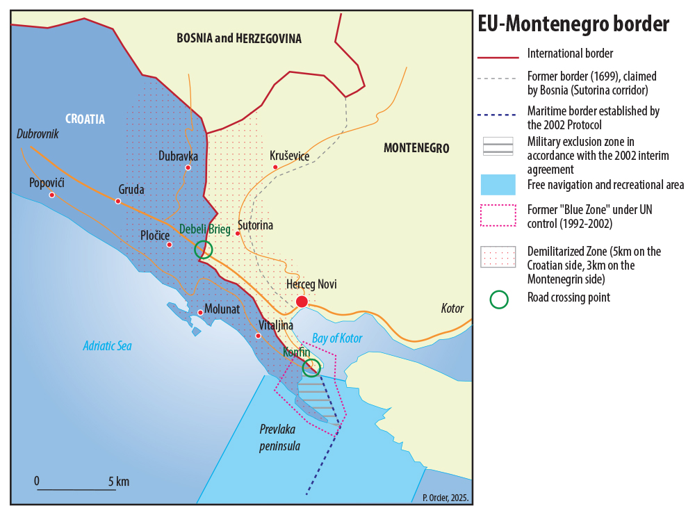
4.4. The border EU-Montenegro
It is in fact the shortest land border of the continental European Union with a neighbour state (25 km) and its shortest maritime extension at the entrance of the Bay of Kotor. It was a front line during the Yugoslav wars from 1991 to 1995, when Montenegro stayed in the Yugoslav Federation on the side of Serbia. The delineation of the border was a matter of dispute between the two countries until the agreement found in 2002 which foresaw the demilitarisation of the zone. In fact, applying the Convention of the Law of the Sea meant that the Prevlaka peninsula gave Croatia de facto control over the Bay of Kotor, which forms the interior waters of Montenegro, and over the inflows and outflows. Without an agreement in the matter, a UN mission remained on site until 2002. Both states are NATO members today. In the past, this border had already been a frontier between Venetian, Ottoman and then Austrian possessions with the constitution of a corridor that gave sea access to Bosnia, an enclaved state, at the level of the Montenegrin city of Herceg Novi. This town became a major local tourist attraction, as the border crossing was easier for the Bosnians than the one at the Croatian border, since Croatia had become member of the EU in 2013 and striving for integration into the Schengen area (definitive membership in 2023). The only road passage between Croatia and Montenegro is the last section of the “Magistrale”, this Dalmatian coastal road that links Rijeka and Montenegro over several hundreds of kilometres. This road was built on the initiative of the French, as Napoleon had annexed the “Illyrian provinces” which were Austrian until then, from 1809 to 1814.
 |
5. The borders in Western Europe
5.1. The border EU-United Kingdom
 |
The border EU-United Kingdom consists of a long maritime section both in the North Sea, according to the line of equidistance defined at the end of the 1960s, and in the Channel, taking into consideration the Channel Islands. The Franco-British demarcation agreement was concluded in the Treaty of Canterbury in 1986, a necessary preliminary to digging the Tunnel under the Channel, which was open for traffic in 1994, and of which no segment could be outside of national rule. Until then, the UK, traditionally attached to the freedom of the seas, satisfied itself with the three-miles-zone for its territorial waters, whereas France had opted for the equidistance rule, which left a high seas area between the Straits of Dover and the Atlantic. Nevertheless, it is France which manages the border before the tunnel and at the ferry terminals, according to the Touquet Agreement of 2002. For the last twenty years the Channel has become a passage route for migrants heading to England. Reinforcement of controls, installation of fences and surveillance cameras led the migrants to take ever bigger risks in their attempts to cross over to the other side. Improvised encampments grew on the northern coast of France, regularly taken down by the authorities. The dismantling of the “Jungle of Calais” in 2015 with its thousands of occupants was widely publicised without bringing forth a sustainable solution. Since that time, smuggler networks operate there, and the crossing of the Channel is associated with tragedies, be it through dead bodies found in lorries or cases of drowning. France has reinforced its means of security in the sea, as the number of migrants is increasing despite dissuasive measures taken ahead and ensuring that migrants are kept informed of the risks. |
|
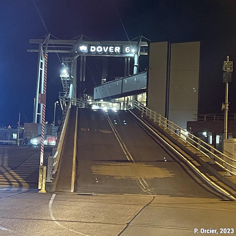
Ferry loading ramp at Dover terminal. Photo: Pascal Orcier, April 2023. |
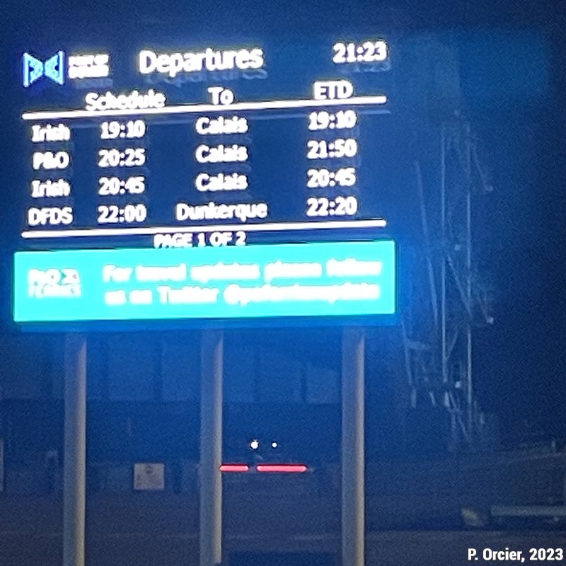
Timetables and destinations of ferries departing from Dover. Photo: Pascal Orcier, April 2023. |
|
View of carparks and Dover ferry terminal. The famous cliffs in the background. Photo: Pascal Orcier, April 2023. |
|
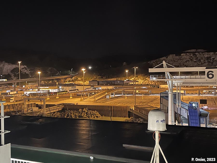
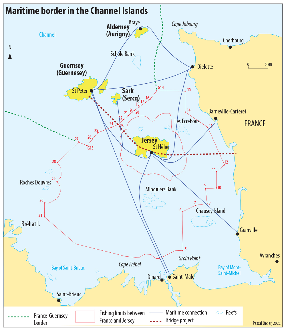
The Channel Islands
The Channel Islands are a little historical and legal curiosity. They consist of the main isles of Jersey, Guernsey, Sark, Alderney and Herm, not part of the United Kingdom, but dependent on the British Crown. They were never part of the EU, just like the Isle of Man in the Irish Sea. There are 160,000 inhabitants on the Channel Islands which are regarded as tax havens or at least as centres of offshore finance. Fishing is a traditional activity. The Granville Agreements of 2002 defined fishing zones, fishing volumes and a number of licences for French fishermen. The Brexit Agreement of 2019 which overrode all the previously signed agreements has revived the tensions between the professionals in the area, necessitating even the presence of the British Navy.
5.2. The border EU-Monaco
 — Monaco") |
 — Monaco") |
This border is quite special as it is at the same time open, in the urban zone, visible and unclear.
The Principality of Monaco is isolated within the French département of the Alpes Maritimes, neighbouring the communes of Cap d’Ail and La Turbie in the west, Beausoleil in the north and Roquebrune-Cap-Martin north-east, with which Monaco is continuous as a city. The Principality is the centre of a dynamic transborder labour market, feeding the economic activities of tourism and luxury goods, but also banking and finance, diversified events and cutting-edge industries.
Although the entrance to the Principality is clearly visible with flags and signs, it is particular in the way that it happens through subterrean road passages, either by railway or via the ramp to the motorway coming from Nice. The increase in road traffic caused a lot of nuisance due to the restricted territory, and led to the need to optimise land use, pushing the Principality to start large infrastructural projects in the 2000s. They came along with the wish to improve life conditions and took into account environmental issues. One enters Monaco mostly by tunnel. The technical challenges caused by the physical conditions (strong inclines) and the size of the territory (which is rarely wider than 500 m) explain why these tunnels were built across French and Monegasque land. In these instances, the border is indicated inside the tunnel. The road tunnel “descending” from the motorway has both entrance and exit in Monaco but makes a loop under the earth in French territory, which is why it has its own bilateral convention. The situation is more complex with Beausoleil where the border does not follow the streets. Sometimes, it goes along, sometimes, it passes between two parts of the same building. Now the town planning rules are not the same in both countries, and the extremely expensive real estate in the Principality has favoured high rise buildings. Blocks of the early 20th century have given way to sky-scrapers several dozen levels high, robbing Beausoleil of its former views. No less than 24 streets and 14 stairways and pedestrian passages connect the two communes.
Toponymy sometimes maintains the unclear outline of the border. The access tunnel to the Principality from the A8 for instance, open since 1992, is called the “Tunnel of Monaco”, the same as the “Monaco Junction”, although both are totally in France. The Principality participated to the financing of several infrastructures, which in part serve its own access, but which are on French territory, like the railway tunnel and the future motorway junction of Beausoleil. In the same way, the fact that many streets keep their names across the border does not help. The Larvotto Boulevard and the Princess Grace Avenue continue beyond the Principality all the way into the commune of Roquebrune. On the French side, the D6007, former RN7, historically surrounded the Principality, serving Beausoleil, but has the name of “Avenue Prince Rainier III”. The carpark near the train station Monaco-Monte-Carlo (opened in 2001) is on French territory but its only access from the Principality is via the tunnel. Eventually, the lack of land explains the number of Monegasque ground rights and real estate (ie belonging to the Principality and to Monegasque nationals) held in the neighbouring communes. The Country Club of Monaco, where the tennis cup of the same name is held, is located on the commune of Roquebrune. The same applies to the radio transmitters of La Madone, installed since 1965 for RMC (Radio Monte Carlo) and the princely residence of Roc Agel which towers over the Principality, on the commune of Peille.
Added to this, the outline of the border was modified because of the sea extension undertaken by the Principality since the late 1960s in order to mitigate the lack of space. The construction of the central strip of the Fontvieille quarter and the Louis II Stadium allowed the creation of the new neighbourhood of Saint-Antoine on the French side and the new marina of Cap d’Ail. This technical and real estate operation was, by the way, financed by the Principality. In 1985 France recognised Monaco’s own territorial waters in the Mediterranean, of 1.9 km wide over 85 km long.
|
The Principality of Monaco seen from the Mont Gros mountain (commune of Roquebrune-Cap Martin). The vertical urbanism prevails, due to lack of space and the high price per square metre. Photo: Pascal Orcier, 2010. |
Between Monaco and Beausoleil, streets and buildings are intertwined, with many road and foot passages. Photo: Pascal Orcier, 2017. |
")
 et Beausoleil (France)")
5.3. The border EU-Andorra
 |
Port Envalira Pass is the highest point of the “route de France” (CG2), between the Pas de la Casa and the remaining Principality of Andorra. An alternative route was created by a 2900 m tunnel, which, at 2050 m altitude, makes it the highest of the big tunnels in Europe. Photo: Pascal Orcier, July 2017. |

Andorra is another enclave in the EU, but with a context and operation quite different from Monaco. Situated in the middle of the Pyrenees mountain chain, surrounded by 2000 m peaks, it is organised along a central valley, which is the main road crossing the Principality from the Spanish to the French border. Away from major French and Spanish cities, its access was blocked for long periods by winter snowfall, a problem subsequently overcome by the construction of the Envalira Tunnel allowing road traffic (the Principality has neither train nor airport).
Due to low taxes applied to consumer goods, Andorra sees heavy daily cross-border traffic flows over the last decades. Both entrance and exit points are, other than in Monaco, regularly controlled by French and Spanish customs. The exportation of alcohol, tobacco, perfume, petrol and consumer goods is in fact limited. This does not seem to hinder the continuous flow of vehicles towards the shopping centres at the entrance of the Principality, built after extensive earth moving works. Andorra features no less than 35 filling stations on the main road from Spain to France… which is just 38 kilometres long!
The border is open and Andorra is in fact included in the Schengen area, although it did not sign the Convention. The euro replaced the French franc and the Spanish peseta in 2002, but Andorra had to wait until 2015 to be allowed to mint its coinage with its own national side, after bilateral agreements with the European Commission, without officially being a member of the euro zone.
5.4. The border EU-Switzerland
 |
Switzerland having decided to stay outside of the community project, its territory forms an enclave in the middle of the EU since the integration of Austria in 1995. However, since Switzerland’s adhesion to the Schengen area in 2008, there are only some customs controls along a very winding road mostly high up in the mountains. Two more enclaves have to be added to the Swiss territory, one, Italian, is Campione (south), the other is German, Büsingen (north), both are the result of history’s vagaries. Because of its winter isolation, the Italian town of Livigno benefits from a special customs status. Many bilateral agreements regulate its relations with the EU, Switzerland’s first economical partner, where tens of thousands of workers enter on a daily basis. Switzerland and Liechtenstein have shared a customs and monetary union since 1923. |
 |
This very old passage between Italy and Switzerland at more than 2400 m of altitude is open only from the end of May until mid-October because of snowfall. The pass itself is in Switzerland, as is the hospice, built in the Middle Ages to welcome travellers and pilgrims on their way to Rome. The vestiges of a Roman fort have been unearthed, in part thanks to EU funds, and its discovery recalls the continuity of this very old strategic passage. Like most of the great Alpine passes, it has large car parking spaces around the buildings which offer hospitality and accomodation as well as souvenir shops. The pass is the starting point of hiking trails on foot or mountain bike, but is in itself an attraction for motorcyclists and other day visitors. |
|
|
The border follows the stream that ends in Lake St Bernard and is indicated by a series of signs on the ground. The border crossing is via a bridge with still alternating one way traffic, each country carrying out the snow clearance on its side of the bridge, but not necessarily at the same date. Only tourist vehicles use this road since the opening of the road tunnel and the covered route in 1964, 600 m down, which allow passage all year round. |

6. The overseas borders of the European Union
From its foundation, the EEC (European Economic Community) incorporated certain overseas territories, recognising at the same time specific relationships with other “overseas countries and territories” (article 131, annex IV). These provisions were resumed and specified along the statutory evolution of the different territories. The EU distinguishes Outermost Regions (OMRs), which are part of the Union (Guadaloupe, Martinique, Guyana, Reunion, Mayotte, Saint-Martin – French part – Canary Islands, Azores, Madeira), from Overseas Countries and Territories (OCTs) depending on a member state but not being part of the Union. Because of the status of the OMRs, the EU has land and sea borders outside of Europe, some of which are dependencies of other EU member states. The territories in question being mostly islands, these borders are essentially maritime.
 |
6.1. French Guyana
 |
The main overseas land border of the EU is the one separating French Guyana from Brazil (730 km), mainly on the Oyapock River. The border with Surinam is also well guarded because of illegal migration across the Maroni River. These rivers constitute essential access routes between the coast and the hinterland, connecting populated areas and serving cross-cultural border territories. Because the old delimitations are often unclear, as the rivers change their course over time, a new delineation agreement was found in 2019 between Surinam and France over the Upper Maroni, due to disputed sovereignty of certain islands. On the Oyapock, the construction of a border bridge did not contribute to developing exchanges with neighbouring Brazil: the visa regime, the need for car insurance in the French territory and the localised character of migrations explain the weak frequentation. However, the bridge which cost 50 million euros was meant to be a symbol between France and giant Brazil. |
6.2. Saint-Martin / Sint Maarten
|
|
The Island of Saint Martin has a particular situation, as it has been partitioned since the Treaty of Rijswijck (1697) between France (North) and the Netherlands (South). A border of 10 km, neither visible nor controlled, separates two entities dependent on two EU member states. The French part became an OMR after its establishment as a territorial community (35,000 inhabitants) distinct from Guadaloupe, whereas Sint-Maarten, the Dutch part, became a OCT after the dissolution of the Dutch Antilles in 2010. |
 et Sint-Maarten (hors UE)") |
Monument marking the frontier between the Saint-Martin OMR (in the UE) and the Sint-Maarten OCT (outside UE), with the date of 1648. Photo: JB82, 2010, license CC by sa (source). |
, dans les Antilles")
6.3. Mayotte
 et les Comores") |
Mayotte, in the Indian Ocean, became a French department in 2011 (as a single authority) and therefore subsequently a OMR and, as such, an integral part of the EU. Its sea border with the Republic of the Comoros was established as late as 1975. It was contested by the latter which claimed sovereignty over the entire archipelago, and is closely monitored because of the influx of clandestine migrants since the 1990s. The boats called kwassa-kwassa regularly attempt to reach Mayotte from the Comorian island of Anjouan, 40 km away. More than half of the Mahoran population is supposedly foreign and illegal, and at risk of deportation. In 2023, faced with a deterioration in safety and social conditions, the French authorities launched the operation Wuambushu (“get a grip” in Mahoran), destined to destroy slums and arrest illegal residents with a view on legal deportation. The territory, on its own, is responsible for up to 30,000 expulsions per year, which is as much as the whole of metropolitan France. The application of the French “law of the land” has resulted in a “childbirth tourism” explaining why the maternity ward of Mamoudzou registers near 10,000 births per year. |
|
>>> Read also: Fahad Idaroussi Tsimanda, « Migrer pour un bidonville. La vulnérabilité socio-économique des migrants comoriens à Mayotte », Géoconfluences, janvier 2023 [in French]. |
6.4. The Canary Islands
|
|
An Outermost Region (OMR) of the European Union, the Canary Islands consist of a seven island archipelago in the Atlantic, the island nearest to the African continent being at about 100 kilometres distance from Morocco. This situation allows Spain to have a considerable EEZ. However, part of this zone is contested by Morocco, whereas Spain claims the officially Portugese Selvagens Islands. The proximity with Africa accounts for the strengthened surveillance of the maritime border because of the repeated attempts of illegal entering by boats with sub-Saharan migrants, in spite of the dangers of such a crossing in poor conditions. |

Conclusion
The border manifests itself across perceptions as well as in the landscape. It comes with specific constraints in the different territories. New or old, seen as definitive or only temporary, the border of the European Union appears, today, as a strong division on the scale of the continent and its near territories. It is attractive to migrants in the search for a refuge, repulsive to private investors, and as such it structures the architecture of relationships and exchange on the continental scale. To be a member or not of the EU has, for a state, specific effects on the workings of frontier territories. Our tour might show the extreme variety of situations and configurations. This border full of history and stories provides a specific geographical subject for the study of how globalisation functions.
Sea also
- Valerio Vincenzo photos about erasure of internal borders in the EU.
- Eurobroadmap, visions of Europe in the World
References
- Michel Foucher, Le Retour des frontières, CNRS Éditions, 2016
- Michel Foucher, La bataille des cartes. Analyse critique des visions du monde. Cartographie de Pascal Orcier. Paris, François Bourin éditeur, 2010, 176 p.
- Jean-Christophe Gay, La France d’outre-mer, Armand Colin, 2021.
- Pascal Orcier, « Quels élargissements futurs pour l'Union européenne ? », Géoconfluences, août 2022.
- Pascal Orcier, « Le Brexit, et après ? », Géoconfluences, article de mai 2020 régulièrement tenu à jour depuis.
- D. Ortolland et J.-P. Pirat J.P., Atlas géopolitique des espaces maritimes, Technip, 2010.
- Bruno Tertrais et Delphine Papin, L’Atlas des frontières, Les Arènes, 2016, 140 p.
- Olivier Zajec (Auteur) Frontières. Des confins d'autrefois aux murs d'aujourd'hui, éd. Chronique, 2017.
Pascal Orcier
PHD and teacher in geography, lycée Beaussier, La Seyne-sur-Mer
Translated from French by Charlotte MUSSELWHITE-SCHWEITZER
Web layout : Jean-Benoît Bouron
Cite this text:
Pascal Orcier, « Borders and Border Territories in Europe: a Guided Tour », Géoconfluences, 2020-2024. Translated from French by Charlotte Musselwhite-Schweitzer in September 2025.
URL: https://geoconfluences.ens-lyon.fr/programmes/dnl/dnl-hg-anglais/borders-and-border-territories-in-europe-a-guided-tour
Pour citer cet article :
Pascal Orcier, Traduction : et Charlotte Musselwhite-Schweitzer, « Borders and Border Territories in Europe: a Guided Tour », Géoconfluences, septembre 2025.
https://geoconfluences.ens-lyon.fr/programmes/dnl/dnl-hg-anglais/borders-and-border-territories-in-europe-a-guided-tour


